
Terrain/ Elevation Data is the first type of data that must be loaded in a new Infraworks file. This does 2 things: provides a base for the entire model and tells Infraworks where in the world the model is located.
Both Terrain and Ground Imagery Data are added as Raster Files. But looking at that long list of file types, how do you know which ones to use for Terrain?

Though I have not yet used all of these file types, Global Mapper (another GIS mapping program) has an excellent list with descriptions of Elevation Formats and Raster Formats. There is some overlap between these two lists, since some of these file types can have both Elevation and Image data.
In General, the Terrain files are listed toward the beginning. Formats in bold are ones that I have found and used:
.adf Arc/Info Grid.
.asc Arc/Info ASCII.
.bt Binary Terrain
.ddf Database Definition File
.dem Digital Elevation Model
.dt0 .dt1 .dt2 Digital Terrain Elevation
.grd Grid File/ Gridded Data
.hgt Height, from SRTM
.img ERDAS IMAGINE.
It also lists .zip and .gz, which are both compressed file formats, but I have not been successful in loading them into InfraWorks.
—
Here are what seem to be the most common formats (at least in the US), and how they appear graphically at different resolutions…
.hgt Height, from SRTM (Shuttle Radar Topography Mission). elevation data (from around the world) collected by NASA in 2000.
This hgt is at 300 foot/ 90 meter (3 arc second) resolution

.adf Arc/Info Grid. a proprietary binary format, as opposed to .asc Arc/Info ASCII, which is an exchange (non-proprietary) format.
This adf file is at 100 foot/ 30 meter (1 arc second) resolution

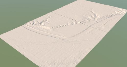
.img ERDAS IMAGINE. another format, developed by ERDAS.
This img file is at 5 foot/ 1.5 meter (1/20 arc second) resolution
So in conclusion, as long as you have an elevation/ terrain file, it doesn’t seem to matter what type it is. From my experience, I would recommend .adf, .img, or .dem (Digital Elevation Model, developed by the USGS).
What does matter is the resolution (adf and img looked the same at the same resolution). The finer the resolution, the larger the file size, which also results in longer download and load times (once in InfraWorks). So the size and scale of the region should determine what resolution is most appropriate.

the Ordnance Survey in the UK provide open data for terrain. It’s in .asc format, but works perfectly well for the resolution.